A shot out of the window of a small plane departing ADQ shows the main runway and the Grand Prize at the end, Barometer Mountain. An aircraft, with its landing lights on, waits at the base of the mountain, ready to take off when we clear out of its airspace. October 1996.
A Look Back: NHB (the Navy Base)
The runways at Kodiak’s main airport were built by the military in the run-
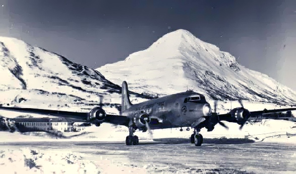
This beautiful winter shot from the early 1950’s shows a Navy transport, perhaps
a DC-
Introduction: Coming In For a Landing
In other articles in this continuing “How to Get to Kodiak” series on Kodiak transportation, I have concentrated on the Grumman amphibians (my first love, surely) and the Lockheed Constellation, both stars of a bygone era. There will be a few photos of them slipped into this article as well. But Kodiak has ongoing fame, including being featured in video games and articles on the “world’s most dangerous airports” because of the unusual placement of its main runway. The famous Barometer Mountain is right at the end of it!
Shaped like a pyramid (but Pyramid Mountain is across the valley to the north), Barometer is the subject of perhaps the oldest Kodiak weather joke in existence. Its first version is most likely carved on the wall of some prehistoric cave. The joke goes: “That’s Barometer Mountain. If there are no clouds around it, then it’s about to rain. If there are clouds around it, then it is raining!”
Until the early 1970’s, the Kodiak airport had the military designation NHB, which according to local legend stood for “Nice Hungry Bears.” It would have been a lot more fun to keep that designation! In part one of this article, a few of the best photos from my collection tell the story of the airport known as NHB better than my prose ever could, but my photo comments add the little details I’ve collected over the years. Part Two chronicles the more recent history of the airport, after it changed to ADQ. PART TWO Part Two also chronicles the little airstrip in the middle of town known as KDK, and the place it has in the history of Kodiak aviation. The topics of this article (and any of the others on Tanignak.com) are not complete by any means, and are merely what I happen to have collected and researched. So if you have any additions or subtractions, I will adjust these articles accordingly. I want them to be as accurate as possible, while still telling a story rather than writing a formal history. So contact me at Tanignak@aol.com with any comments you may have, and of course, if you have any photos or stories to share, that would be great, too. You will notice the sources of many of the photos and stories, and I greatly appreciate those who participated!
Kodiak Airport: You’ve Got to Be Kidding!
The military end of the runway at NHB, and the reason it was built in the first place, was the Naval Communications Station (NavComSta). Here one of the massive hangars dwarfs the transport planes that await their next mission in a photo from a book by Yule Chaffin. All book photos are used by permission of the Yule Chaffin estate.
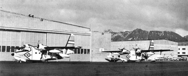
A shot of the Coast Guard hangars at the Navy base. (Yule Chaffin estate)
The whole base would become a Coast Guard facility after 1971. The photo shows the big sister of the Goose and Widgeon, the Grumman Albatross. Two of them sit on the tarmac waiting for distress calls, weather missions, and tracking foreign trawlers who strayed too close to American shores.
The military issue of the Albatross was easily identifiable due to the bulbous black dog nose, which housed antenna equipment. Later the amphibians were replaced primarily by Sikorsky amphibious helicopters. But the late 1950’s and early 1960’s were clearly the era of the Grumman amphibian on Kodiak Island, both for the Coast Guard and for the commercial ventures such as Kodiak Airways and Bill Harvey’s Harvey Flying Service.
NHB: the Commercial Airport
Along with the military traffic, Kodiak was also a commercial airport, as local canneries
discovered that air transportation of seasonal workers was financially viable. As
the town grew, and the outlying canneries increased production, arrival in Kodiak
by air (as opposed to by steamer) became more and more popular. Shortly after I was
born, the airlines’ main competition, the Alaska Steamship Company, ceased passenger
traffic to Alaska and became a freight-
Above: this beautiful shot of a Pacific Northern Airlines “Connie” (Lockheed Constellation)
on the tarmac at SEA-
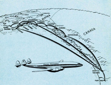
More memorabilia: this composite graphic from a 1955 Pacific Northern Airlines brochure advertises the new “Connie” service with a package of tours and cruises based on PNA’s flight routes.
During the years when the “Connie” served Kodiak, there were regular direct flights from Seattle to Kodiak, although PNA never really capitalized on any tourism connection for Kodiak. That route was mainly to service the many canneries that operated up and down the Kodiak Archipelago, and to provide regular commercial service for the Navy and Coast Guard bases in Kodiak.
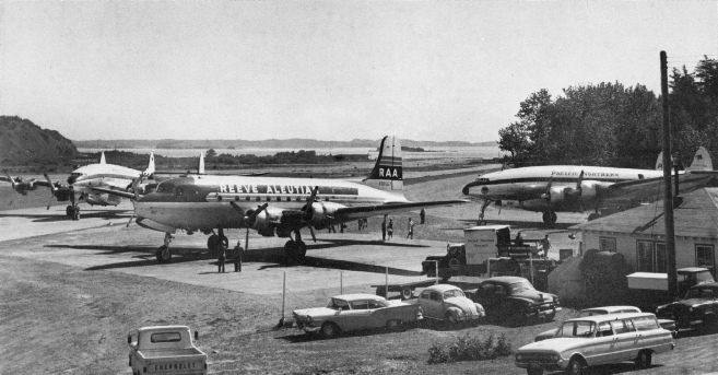
This very rare photo of the Kodiak airport, circa 1961, shows two Pacific Northern Airlines “Connies” and a Reeve Aleutian plane.
Most likely this photo was taken at a time when the demands for out of state workers
for the canneries around Kodiak Island prompted a sudden rush of incoming passengers.
Workers from out of the country would arrive at West Coast ports and make their
way to Seattle, the “Gateway to Alaska,” and catch a flight to Kodiak and the other
fishing communities. It documented Kodiak as it was just before the earthquake and
tidal wave of 1964, and is full of rare photos of island life as it was before the
great disaster wiped so much of it away forever. This and all the other Chaffin photos
was scanned from an ultra-
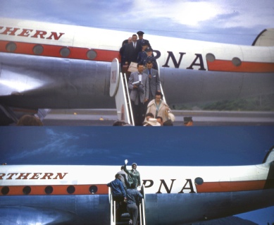
Arrivals and Departures: For the better part of two decades the “Connie” was the link to the outside world for thousands of visitors and residents of Kodiak Island. In these photos, the arriving passengers include several uniformed Navy personnel, and the departing passengers include my older sister Jerilynn (turning and waving to the camera) heading off to McMinnville College in Oregon.
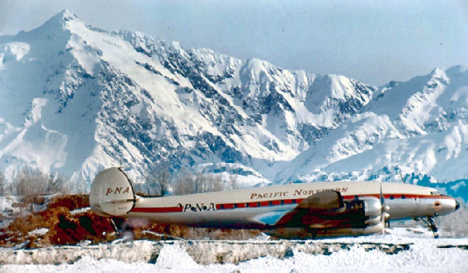
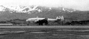
Right: my pathetic first camera didn’t do justice to this historic scene: one of the last PNA Connies prepares to depart from NHB in the late 1960’s. Oh for a long lens and color film! Above: this lovely shot of a Connie with mountains behind could have been taken at Kodiak, but was actually taken in Yakutat. It’s what the photo on the right should have looked like! The above photo was provided by Norm Israelson, who sent me other great photos (and a lot of stories) for my article, “PNA Connie Tales.”
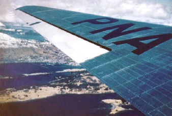
Steve Harvey took this photo out of a Pacific Northern Airlines DC 3, which the company used for their shorter flights within Alaska. The photo from around 1960 or 1961 shows the first Kodiak boat harbor in center left, below the flap. Most of Kodiak’s downtown and shoreline was destroyed in 1964 by the tsunami.
Tragedy: a Kodiak Airways Widgeon crashes on takeoff near the end of the NHB runway
in May 1969 (photographer unknown). Thankfully this is one of the few times the runway’s
emergency equipment has ever been put to use. Kodiak pilots are among the best on
the planet — they have to be! This plane became one of the pieces for N85U (see Part
Two in the section on KDK for what happened to that ill-
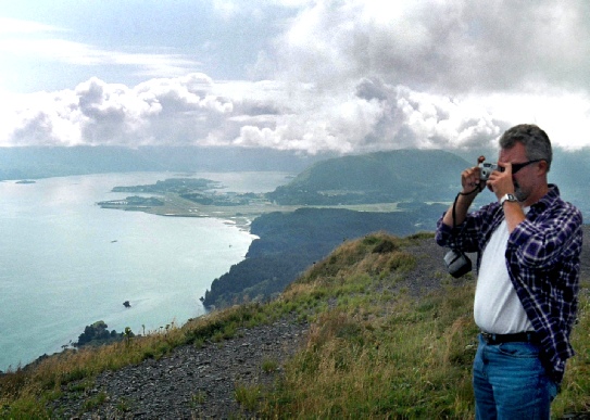
My brother Kelly stands atop Pillar Mountain snapping a photo of Woody and Long Islands
in the distance. The famous Kodiak Airport appears in mid-
Link to Part Two:
(NHB’s Transition to ADQ, and The KDK Airstrip)
Acknowledgements:
I wish to thank Dirk Sundbaum, a Kodiak Western Alaska Airlines (Kodiak Airways) employee in the early 1970’s, for the photos which contributed so much to this essay.
I also thank the estate of Yule Chaffin for the use of several photos from Yule’s first book, Alaska’s Kodiak Island, published in 1962 (written with G. C. Ameigh, Jr.)
Finally, I wish to credit Fred Ball, master Grumman amphibian pilot, who helped me identify aircraft, correct mistakes, and clarify wording throughout. His photos (and my photos of him in action) are featured in the article “Goose and Widgeon – Still Flying” here at Tanignak.com.
Timothy Smith, web author, 7/2011 (minor revisions 2/2020).

Runways to Remember, Part One (NHB and ADQ)
By Timothy Smith, Originally posted in 2011, latest revision in 2020
Runways To Remember Part 1
Part of the “How to Get to Kodiak” series of articles
(NHB and ADQ in Kodiak Aviation History)
This plane’s eye view of ADQ airport and part of the Coast Guard base in the early 1970’s is from the collection of Dirk Sundbaum, who provided many other photos in this article. Barometer Mountain (left) and Pyramid Mountain (right) are Kodiak landmarks.


Right: The same runway in cloudy weather reveals its true danger, which only grows worse as the cloud cover gets lower. There can be no overshooting of this runway, and an aborted landing would be tough to negotiate! Summer 1998 photo




For more on Kodiak aviation, including much more information on the Goose and Widgeon, and many more historic photos, please follow the links in the photos below.


To Find Out More About Tanignak.com, Click HERE
To Visit My “About Me” Page, Click HERE
To Return to Tanignak “Home,” Click the Logo Below:


Information from this site can be used for non-