New for the 60th Anniversary:
Scroll to the end for an audio file of the song, “Alaska Earthquake,” by country artist Blue Ervin. It was played frequently on Alaska radio stations in the summer of 1964. It took me almost 60 years to identify and purchase this old 45 rpm record, presented here for the 60th Anniversary.
Introduction to the 2024 Restoration of the 2004 Posting
This little article has been one of the most influential things I have ever written.
Photos featured here have appeared in the Fiftieth Anniversary book published by
the Kodiak Mirror, and the first-
For this new 2024 re-
However, I have done little to the original text but correct grammar and wording. When I wrote this article on the fortieth anniversary of the 9.2 quake and resulting tsunami, the memories just flowed out of me, and I doubt if I could improve upon it if I rewrote it. Astute readers will notice that I keep referring to “Tidal Waves” as opposed to Tsunami. In 1964, none of us had heard the Japanese term, and used the common wording of the day, so in keeping with when this happened, and how we referred to things, that phrase will stay. Here is the original 2004 fortieth anniversary article, with new and restored photos.
The Original 2004 40th Anniversary Article
It is March 27th, 2004 as this is being written. It has been forty years since that day. None of us who were there will ever forget where and what we were doing when the world changed forever. Kodiak Island is still a wild and remote place, and in 1964 it was even more so. We were used to strenuous living and inclement weather, wild winds, blizzards and weeks of drizzle and fog. But what happened on Good Friday, 1964 was of such awesome power and magnificent forcefulness that it completely altered our opinion of Nature and confounded everyone, from the most eminent geologist to the most secluded homesteader.
The event was the Great Good Friday Earthquake of March 27th, 1964. It was first
thought, and widely reported to be a massive 8.6 on the Richter Scale, but subsequent
earth measurements have caused seismologists to reclassify it as a phenomenal 9.2,
the largest quake ever recorded in North America. It caused the most destructive
and wide-
The Quake and the Immediate Aftermath
We made our way outside, and I noticed in disbelief that the doorframe of the back porch was moving back and forth, and up and down more than its width. I was hit by both doorframes as I waddled through the doorway, and I was a narrow little lad at the time! We sloshed through the thick snow that still lay crusted in the backyard, and huddled together on the rock outcropping. It was hard to stand up, even for experienced boatmen like ourselves. Villagers who lived in the gelatinous swampland in the center of town were not so lucky. They reported seeing the ground rolling like a wave before they felt the shaking. A good many of them were literally knocked off their feet, some of them repeatedly. So we huddled together and hugged each other, for practical purposes as much as comfort.
“Would you look at that!” Mom interrupted over the incessant rumble beneath us, trying
to sound clinical and detached, because she saw the paper-
As a California resident from 1978 to 2018, I lived through the Whittier Narrows,
Landers and Northridge quakes. I have lousy luck where earthquakes are concerned!
Most of them were comparatively moderate where we lived, although the Northridge
quake was surely devastating for those close to it. I was sometimes more than forty
miles away from these quakes, and didn't experience the full force. Only the Landers,
which we experienced from only ten miles away because we were staying overnight in
Palm Springs at the time, even came close to the Alaska quake. It rolled around a
good bit, and lasted a whopping forty-
But the Great Alaska Quake lasted for over five minutes, and those unfortunate to
live closer to the epicenter experienced the shaking for nearly seven minutes! We
were about two hundred miles from the epicenter, and still experienced a huge groundswell.
And what we didn’t know was that the whole north end of the Kodiak Archipelago, an
area half the size of Connecticut, sank six feet lower into the sea than before the
quake. That long-
It was finally over, or so we thought. All was quiet, and the peaceful colors and
shades of approaching dusk seemed to deny that anything at all had happened. But
deep on the ocean floor off the coast of the mainland, a huge section of the earth's
crust had been displaced, sinking by over one hundred feet, and the crushing weight
of the ocean scrambled to find its new level. The shock waves of energy were already
traveling toward Kodiak at over 600 miles per hour, and the subsequent slower energy
waves were causing a huge tidal shift which was already heading our way, fanning
out across the coastland, spreading death and destruction in its wake. A full seven
waves were still to come. We imagined no such fate as we went back inside, marveling
that the power was still on and very few items had been knocked out of place. Baker
Cottage had old-
The Tidal Wave Begins, and Fishermen React
I was still a white-
I was surprised to see Albert Torsen’s salmon tender, the Maurine Greer, belching blue diesel smoke against a steadily increasing current, with the Evangel looking tiny and white next to the green hull of the tender. The Torsens lived in Corbett's Cove, a little bay just down the island from the village, and their house was not far above the tideline. Albert had packed up his family and headed for his boat as soon as the shaking subsided, and they were all on board. The Mission Boat Evangel, which my parents ran, had been tied up at the dock. The Maurine Greer was in the process of putting the Evangel out on its mooring, and leaving it at the buoy in the relative safety of the deeper water of the bay. I could see the big twin diesel, twin screw tender churning up a huge wake and hardly moving at all. The fact that they got the Evangel tied safely to the buoy against the outgoing rush of the first wave is nothing short of amazing. Then they turned tail and ran for deep water, suspecting rightly that staying in shallow water or in close proximity to the coastline would be dangerous. That much I saw from Anderson’s hill, around the point from the harbor and the dock. (Continued below…)
The photos were taken by Mr. Carpenter, the storekeeper, in the twilight with a small box camera. But they are Ouzinkie's only pictures of the Tidal Wave in action and are among a very few that exist from any village source. The bigger and more violent waves occurred after nightfall, and continued until the early morning hours. Meanwhile, these boats and several others escaped damage or destruction out in the deep waters of Marmot Bay.
Storekeepers Begin Their Own Adventure
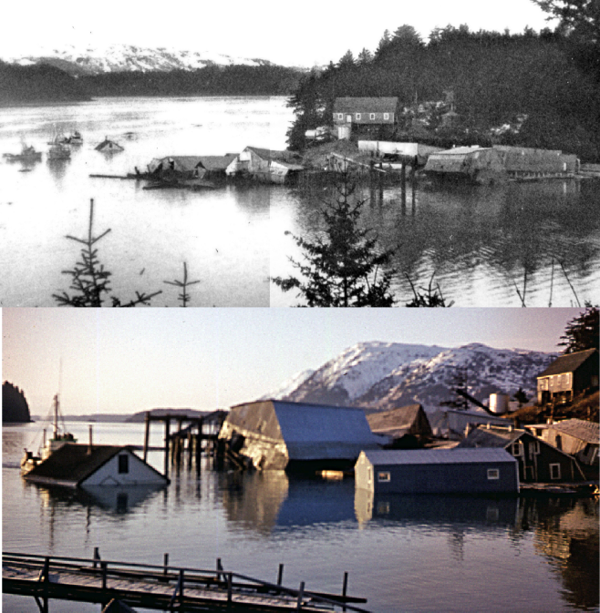
Top: Georgia Smith took this photo in the early morning Ouzinkie in the early morning of March 28th.
I split the photo to process each side of it separately for clarity. The boats had been out in deeper water, but moved closer to the bay in the morning light. The building near them was pushed to shore in the second photo.
Bottom: Dad’s color slide from early the morning after.
Note the water line on the center building, showing the residue of the oil spill. The boat to the far left is pushing the building seen in the top photo closer to shore. The building to the near right was eventually salvaged, as was one smaller one, but none of the others in the water could be saved.
The above photo is typical of beaches across northeastern Kodiak Island for years after the Tidal Wave. All along the Alaskan coast, the wreckage was strewn far inland. There are places on Woody and Long Islands where cans and styrofoam cups and even logs can still be found high up the cliffs, wedged in trees or far back from the cliff face, thrown there by the surf action of the Tidal Wave hitting shallower water. The outlying islands may have served as a kind of breakwater, protecting Kodiak from the full force of the waves.
The Village Springs into Action
That morning after the tidal wave, as I neared the store, or what was left of it,
I was surprised to find a flurry of organized activity. The people of the village
were engaged in a concerted salvage operation. The entire south end of the store
had been sheared away, and the rest of the building sagged in irreparable but momentarily
stable condition, anchored to the shoreline enough to avoid complete destruction.
All of its perishable contents were gone or contaminated by the gasoline-
A plan was underway to sort it all out into piles for each of the families in the village, and soon, everybody was grabbing washbasins and buckets and hauling cans up to higher ground to be distributed. I ran home and asked Mom if I could help, and after she determined that I would be surrounded by adults, she agreed. We dragged bucket after bucket of sodden cans up the hill to a building that was well above the tide line, and gingerly stacked the cans by type, to be divvied up later. We had to be extra careful handling the cans, because the labels were all water soaked and had a tendency to come off. Nobody wanted to open a can of Campbell's and get Friskies Dog Food! When the light faded, I went home bone weary, but content in a small way that I could do something useful in the face of all the tragedy.
The Carpenters, storekeepers for a store that was now destroyed, set up a temporary
shelter in one of the few cannery buildings that was above the new tideline. They
dejectedly went back into their old apartment to see if anything could be salvaged.
Water-
Photos of the Villagers and the Storekeepers Beginning Salvage
Rumors and Misinformation
Unfortunately but understandably, the infrastructure of the State of Alaska was in total chaos. News filtered out from each location in little pieces, much of it wrong. On choir tour with Linfield College in Oregon, my older sister Jerilynn was informed that the entire island of Kodiak had sunk. She steeled herself for the realization that she and her older brother Noel, also out of state and at college, were probably the only survivors of the family. But it turns out that in one of the towns she visited, the host family had a neighbor who was a ham radio operator. He fired up his transmitter and contacted a ham operator in Kodiak, who called us on a CB radio.
We had recently bought a tube-
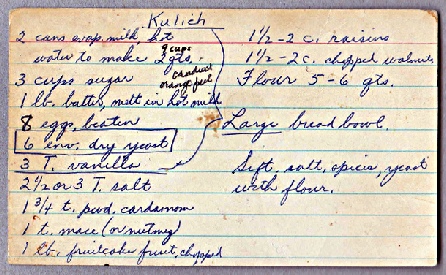
The tale of Kodiak's disappearance was not the only rumor that plagued us in the immediate aftermath of the tidal wave. On Easter morning, Dad and Mom put together their usual full spread of kulich (see attached recipe), hard boiled eggs and hot cocoa for the village, but this time it had a much more practical purpose. Many of the folks who came to enjoy the breakfast and worship with us had lost their homes, and a hot, delicious meal was much appreciated. We were in the middle of an energetic and moving Easter service when one of the local teenagers barged in crying that there was a 200 foot wave coming and that we had to get to high ground now.
Dad tried hard to reason with everyone, because without a massive new earthquake, there would be no cause for such a wave. Besides, the weather had turned awful, with sleet and snow falling and a brisk wind. Heading up into the hills on a day like that would just make a lot of people sick. But fear and panic gripped many in the village, and they spent a long and miserable night up in the hills. There was no official source for information anywhere, and when the rumor started, it spread like wildfire. Mom treated a lot of colds in the days following. (Continued below…)
An Easter service in the chapel of Baker Cottage in Ouzinkie (this photo is from 1966).
Two days after the quake, our service was interrupted by a rumor of another tidal wave, sending dozens of terrified people up into the hills in freezing rain.
Slowly Back to Life
In the next few days, the village slowly struggled to get itself back to life. The new normal of life included extricating fishing boats from people's yards, shoring up or abandoning the housing that still survived, a mostly unsuccessful attempt at salvaging a few of the floating buildings, and the resumption of school. Because the schoolhouse was one of the few places in town (Baker Cottage being another) that had auxiliary generators, there was really no excuse for not going back to school. Let it not be said that we resented going back to school, either. It was a way of touching the familiar and the known. Besides, the village kids had often found themselves in harm's way as they explored the hazardous remains of various buildings that still sagged in the bay. One young man had nearly drowned when he slipped through a loose board in what remained of the dock. A rickety stack of pallets that had been salvaged toppled over into the hole he had created, nearly forcing him under. Luckily, he threw himself under the planks of the dock, and crawled to safety on a floating pile of pallets. It was just as well that we were back at school. Wreckage makes a very dangerous playground!
But things weren't quite normal back at school. One of the Pestrikoff brothers had
a couple of old, outdated marine band radio transmitters, which put out a wide and
uncontrolled signal that had recently been banned in favor radios with quartz-
Peggy Dyson, the Marine Operator out of Kodiak, who could patch a radio call into
a normal phone line (provided you took turns talking, over!) was tasked with calling
all the registered boats to see if they were still operational. It took her several
days to get through her list. I was reading at the kitchen table listening in when
we heard one of her calls: “Marine Operator Kodiak calling the Piggy-
Two Photos of What Happened in Kodiak
Tidal Wave Memories: Ouzinkie and the Great Tsunami
By Timothy Smith, Originally posted in 2004, latest revision in 2024
Tidal Wave Memories, 1964
Memories of the Great Tsunami of March 27, 1964
A First-
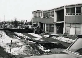
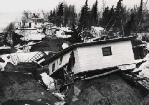
These press photos show the widespread destruction experienced by Anchorage from the earthquake.
All of the damage around Kodiak Island was hours later, as the result of a series of at least seven Tidal Waves, the highest reaching an estimated 35 feet above the tide line, and higher where shallow waters encouraged cresting wave action.
The Quake Begins
Anchorage and many other Alaskan communities had unbelievable damage from that massive shock, but I can’t tell those stories. I can only tell mine. I was ten years old, less than two months from my eleventh birthday, and we had been in Ouzinkie for almost seven years. Since it was Good Friday, we were deep into the preparation for Easter. Our kitchen table was covered with loaves of kulich, Russian Easter bread, baked in coffee cans to mimic the domes of the Orthodox churches. Mom had whipped up a big batch of white frosting, and we had our spatulas in hand to coat each loaf. It was around 5:36 p.m., and the daylight was just beginning to fade. It was flat calm, and the channel between the islands shimmered like a mirror through the trees.
Dad looked up from his loaf and glanced out the window. “What was that? Did you hear that?” There was no need to answer, for the next instant there was a roar like a hurricane or a thousand freight trains, followed by the sickening sensation that the world was falling apart. Old Baker Cottage began to creak and groan, drowned out by the perpetual roar beneath our feet. The floor began to heave and roll, and I, well familiar with life on the open sea, was appalled to observe the walls and the ceiling pitching as though in a broadside swell. After only a few seconds, which felt like an eternity, our senses were racing so, both Dad and Mom said, “We'd better go outside.” It was not proper earthquake procedure, strictly speaking, but what procedure works in an event like this, and how would we know what to do anyway? Afterward, Dad explained that twenty feet from our back porch is an outcropping of solid bedrock with no trees directly overhead, and that seemed safer to him than the creaking, complaining old Mission building. (Continued below…)

Left: Family friend Georgia Smith (Easter 2002) with kulich and eggs. I was at this table on Good Friday, 1964 when the quake struck.
Above, just for fun: Mom’s recipe card for Kulich (Russian Easter Bread), a Ouzinkie favorite.
Meanwhile, out on the Ouzinkie Packing Company dock, around a tree-
The first flutters of the tidal wave were beginning, and the diesel boat soon had
several others in tow, making maneuverability almost impossible. The storekeeper
snapped a few photos in the fading light, showing the boats alternately floating
free and stirring up mud as the water levels in the bay fluctuated quickly. Finally
breaking free into deeper water, or rather ominously, the water coming to them, the
boats disengaged, the gas-
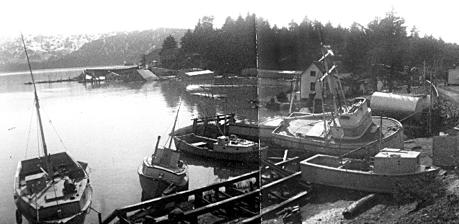
Below is the remarkable photo sequence of the boats leaving the bay in the midst of the first wave of the tsunami, shot by Mr. Carpenter, the storekeeper, in the fading light. Although the originals are in color, converting the photos to black and white allows a lot more clarity in this historic sequence. In fact, the photos are now in a different order thanks to the improved detail.
The photo sequence: The first wave hits Ouzinkie harbor, at around 6 p.m.
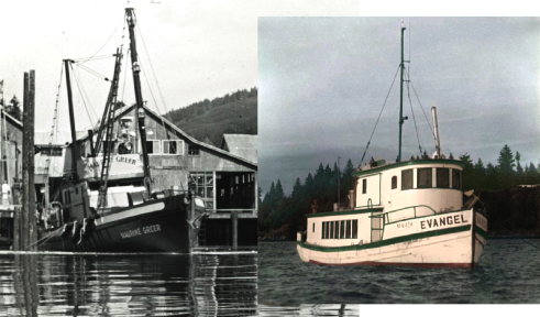
Left: The Maurine Greer at an unknown port on the Alaska mainland. Right: The Mission Boat Evangel at anchor in the bay at Ouzinkie (colorized photo).
The captain of the Maurine Greer tied the Evangel to his boat and took it to its mooring in the bay before escaping to deep water. If left at the dock, the Evangel would have been destroyed when the cannery was destroyed.
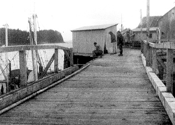
1. Ouzinkie fishermen attempt to save their boats as the first wave comes in. The gasoline pipe has broken, spilling hundreds of gallons of gasoline around the boats.
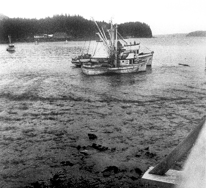
2. The Janice T tries to get to the dock to get the rest of the boats, although the water is rushing out of the bay.

3. The Janice T makes it to the dock, but the receding wave leaves it high and dry.
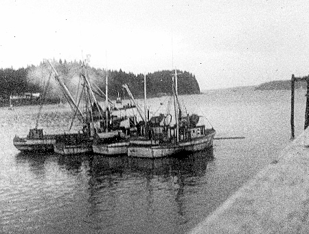
4. Within a few minutes, the water returns again, and the Janice T, billowing white diesel smoke, tows the other boats out to safety in the deep water of the bay.
The Carpenters, a couple hired by Ouzinkie Packing Company as storekeepers, were working in the new addition to the store, butchering some beef to put in cold storage, when the quake hit. When the shaking subsided, they walked out onto the dock to inspect the damage. After photographing the fishing boats as they attempted to leave the dock, they happened to look back at their apartment, which was built closer to the beach, a few steps lower than the store. Water was already lapping the floor.
They rushed back inside and grabbed what they could. By the time they reached the doorway, arms full, the water was already waist high. Mrs. Carpenter looked down and noticed with dismay that she and her husband had removed their wedding rings earlier to work with the meat, and had left them on a dresser back in the apartment. As the light faded, she could hear the sound of the outer cannery buildings being lifted from their pilings and shifting and collapsing, and knew she would never be able to retrieve their things. Quickly, Mr. Carpenter led them to higher ground, and they joined a procession of other villagers high on the bluff overlooking the bay. Many did not stop until they were far beyond the shore, high up on the hill beyond the village. Most of them spent a cold and miserable night in the slushy, melting snow on the ridge above the village, with hardly anything with them except the clothes on their backs.
Back at Home: the Night of March 27th
Meanwhile, I ran home to tell Dad what I had seen of the Evangel and what was happening to the bay. We sat back down at the kitchen table, a little more tentatively, to be sure, and Dad turned on the radio. The big receiver in the corner was hooked to a long copper aerial and could pick up AM stations from hundreds of miles away. When the sun went down, I could regularly find stations in San Francisco or even LA, although they faded in and out a bit. KGO in San Francisco and KFWB in LA were favorites of mine. During the daytime time our “local” stations were in Anchorage, 250 miles to the north. What we heard when we first started turning the dial was static and silence. Dad shook his head and remarked that this quake must be something huge. We finally found KFQD, an Anchorage station operating on emergency generators and broadcasting news that sounded like it was the narration of an apocalypse. Rumors of families buried alive in their homes, breaking out of attic windows to crawl out onto muddy ground. Tales of people crushed in the streets as fissures opened by the quake closed solid after the shaking ended. And an endless list of people searching for loved ones and being instructed where to go for help as emergency services slowly staggered to life.
As compelling and shocking as the drama in Anchorage was, it was not local news.
For that, we tuned to the undependable and weak station on the Navy Base in Kodiak,
broadcasting a signal designed to reach not much further than the boundaries of town.
What we heard was more immediately terrifying. The station's traditional tag line,
“This is AFRN, the Alaskan Forces Radio Network, your voice of authority in all local
emergencies,” was replaced by a very young and panic-
Not able to get any more news from that source (the Navy base’s “voice of authority in all local emergencies”) we turned to the shortwave, marine band frequencies. We wouldn't be able to get anything official, but we might hear what was going on in other places as boats reported in. 2450 and 2512 were the two most common channels for boat traffic, and we tuned in 2512. A flotilla of fishing boats had followed the same instincts as our local fishermen, and was heading for deep water. One boat remarked that the water had been over the planks at the Donnelley and Acheson dock when they headed down the channel toward Spruce Cape and beyond to deep water. Another boat, a red and black Kadiak Fisheries seiner actually named the Spruce Cape, was communicating with a boat ahead of it and one behind it as it went through the shallow channel between the rocks off Spruce Cape, a shortcut inside the buoys that the smaller boats always took.
On board was a young husband and father from Ouzinkie, who was hoping to find a way home to his family. I listened as they chatted about how different the rocks looked as the water receded. Then the skipper of the Spruce Cape shouted into the microphone, “Oh, my God! The biggest wave I've ever seen!” There was a click, and silence. The boats ahead and behind watched in horror as the tidal wave, hitting the resistance of shallow reefs, crested into a gigantic surfer’s curl and engulfed the small fishing boat. Many days later, the stern portion of the boat, shaved and shattered, but still bearing the proud white letters, “Spruce Cape,” was found wedged high on the rocks of Spruce Cape. No other trace of the seiner, or the people aboard, was ever found.
As a 10-
But I can only reliably tell our story, from those who lived it. Somehow, Mom put
together some kind of a supper, but I certainly don't remember it. The city power,
provided by a pair of generators down on the dock behind the cannery, had been knocked
out by the tentative first wave, which had been more like a high tide than anything
else, and had done little damage to the buildings. But it was enough to short out
the generators, and they shut off for the last time less than an hour after the shaking
stopped. Dad had a portable generator in the shed out back, and he fired that up,
and kept it running all night. I was put to bed, and actually slept for part of the
night, for I didn't know until daylight that several neighborhood families sought
shelter with us as the water swirled around their homes. Dad said that the basement
of Baker Cottage was forty-
Everyone was subdued and shocked by the transpiring disaster, so they didn't make
enough noise to wake me. But I did awake several times in the night, startled by
the bump of an aftershock, then became aware of a roar like a huge waterfall coming
from the direction of the bay, a sound which was far louder than the hum of our little
generator. It was the sound of cataracts and rapids caused by the tide receding from
terrain that had always been far under water before. Folks who stayed on the cliffs
above the bay remarked later that they saw the Evangel go dry at least three times,
and that was in a deep harbor! They also thought that Dad was aboard, since the skiff
was tied at the stern, and the boat seemed to strangely move out of the way of every
boat and building that came its way. I can't explain that one, except to say that
the mission trips of the Evangel in the summer of 1964 were the most amazing and
encouraging for all the shell-
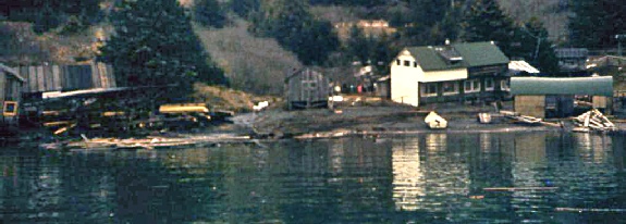
The Opheim family lost the sawmill on the right in the above photo, and a new boathouse for skiff building. They salvaged a lot of their belongings because they went down between waves and tied their home to a large tree! They rebuilt high on the ridge above the bay.

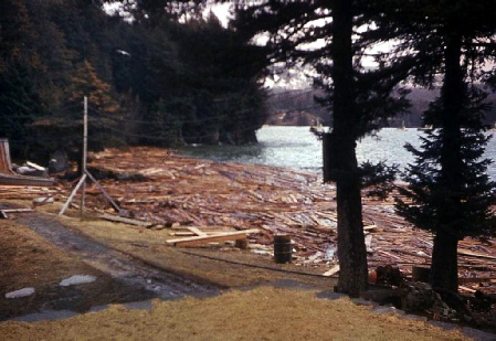
The debris-
A Morning of Shock and Dismay
The morning of March 28th dawned as beautiful and spring-
Out in the channel between Kodiak and Spruce islands, the passage that had roared with a thousand waterfalls the night before now was flat calm, but the ocean was still surging with leftover energy as it sought desperately to find its new level. Houses, boats and bits of buildings floated serenely by as in a river's current, only to float by in the opposite direction a few hours later. Some intrepid fishermen went out with ropes and outboard motors and tried to salvage the floating homes, but lacking any equipment to winch them ashore, or any secure place to put them, they watched as the buildings slowly disintegrated as the tides took their toll. Of all the buildings that floated off, only a couple of small storage sheds were ever salvaged. And random lumber, logs, bits of buildings, and even whole fishing vessels littered beaches for miles in all directions.
Saturday morning dawned on a state that would never be the same again. All up and
down the central coast of Alaska, all that was old and known and familiar was gone
for good. Something was dreadfully wrong with the tides, which still lapped up around
the grass and trees that once had been far from the water's edge. What we did not
know yet was that the entire north end of the Kodiak Island archipelago had sunk
six feet lower. That meant the tides (the regular old moon-
A Photo Gallery of Tidal Wave Damage in Ouzinkie
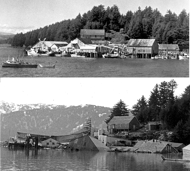
Above: a panorama of the Ouzinkie Packing Corporation’s cannery in the summer of 1962. Below: the buildings after the Tidal Wave, slowly disintegrating and floating away as debris, within a few days of the Tidal Wave. Tons of cannery equipment and pallets of canned crab ended up at the bottom of the bay.

Above: Two photos spliced together show the “ways” in the foreground, where boats were stored for the winter or for repair.
A few boats were deposited up on the banks around the bay, some were carried out to sea, and these were damaged in place, as shown in the photo on the left. Meanwhile, the cannery in the distance sinks lower and lower into the bay.
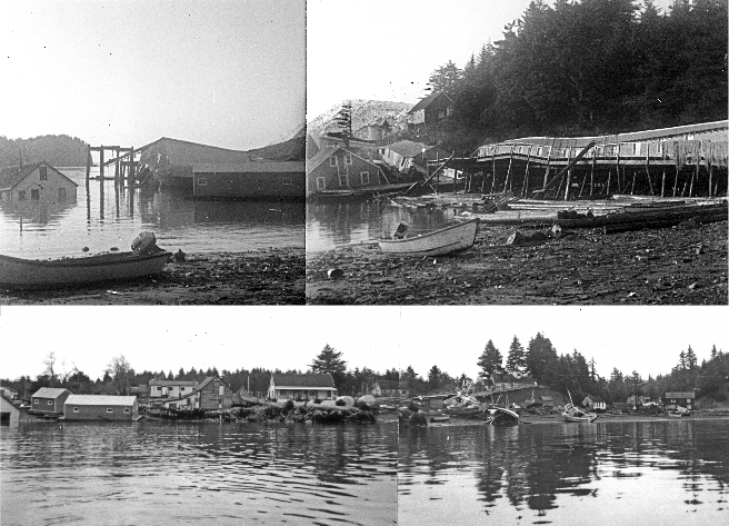
Above: a composite photo of buildings that the folks in the village attempted to save, and the cannery slowly falling apart. Lower photo: Another composite of the shoreline from near the old cannery dock.
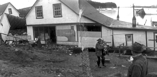
Lack of appropriate equipment meant only two small buildings were salvaged. The two gray buildings on the far left of the lower photo survived for years after the disaster, with new foundations. The house in the center, with the covered porch, survived into the 1980’s.
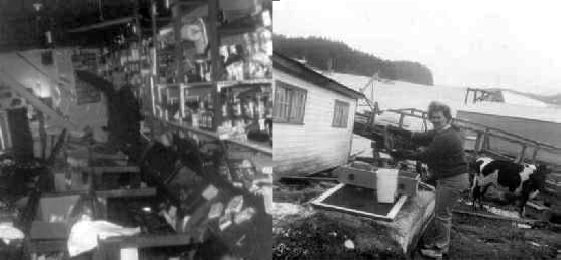
Left: Mr. Carpenter points to how high the water came inside the store as it tore half of the building away. Right: Mrs. Carpenter wrings out some clothes she’s attempting to salvage from a dresser as a cow looks on.

Right: the entrance to the cannery store as it looked from the 1940’s to March 27, 1964, without its new addition, which disappeared in the waves.

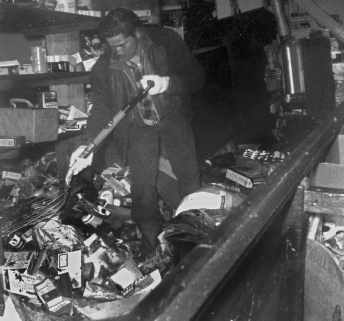

Left: Sorting through the wreckage. Center: Loading cans into buckets. Right: Sorting out the food to distribute to each family in the village. The photo on the right was taken in the cannery office, which was on higher ground and had minimal damage.
Below: Some folks attempted to salvage some of the gasoline-
Below is another remarkable sequence: The citizens of Ouzinkie salvage cans from the store, to distribute to the families in the village. We had no idea how long it would take for the outside world to even check in on us, much less be able to help us.

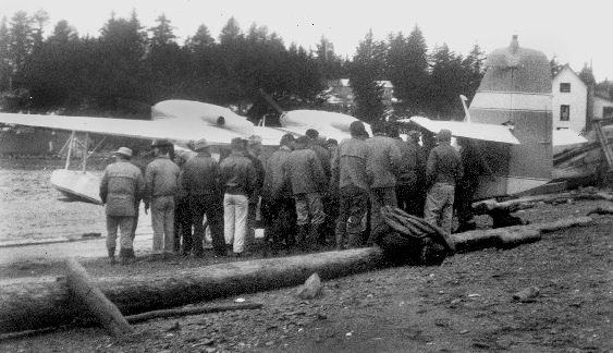
Above: Men from Ouzinkie crowd around the first plane to arrive since the tidal wave, seeking news.
This looks to be Bill Harvey’s Grumman Widgeon, and the pilot can be seen in the side door, talking to the small crowd that’s hungry for any information about what was going on in other villages and in Kodiak. Although a bush pilot and not a government representative, the pilot represented then more than ever the possibility of contact with the outside world, a lifeline to the rest of the world at a time when those of us in the village had never felt more isolated.
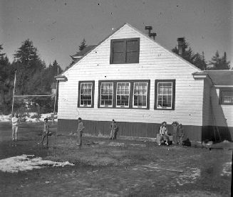
The Ouzinkie Grade School in the 1964-
In the weeks after the Tidal Wave, the “big room” (grades 5 through 8) hosted two constantly monitored old marine band radios as the main link between the village and the rest of the world. We had to study through the chatter, but it was a sense of being a part of history.
Above Left: A huge spruce tree is ready to fall down a cliff, thanks to the erosion of the cliff face below it due to the subsidence. (Travis North photo, 1969)
I’m standing next to a huge spruce tree on the south side of Woody Island, whose roots are almost completely exposed because the ground beneath it, high above the tideline, has been eroded by the higher tides and surf due to the subsidence. The coastal areas affected by the subsidence lost perhaps thousands of acres of former coastline to the erosion caused by higher ocean levels, changing the islands forever. This was the slow motion disaster that befell the islands long after the communities had recovered and rebuilt.
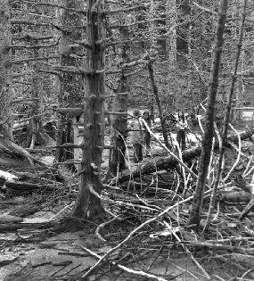
Above Right: This photo is from the north end of Woody Island, near Crab Lagoon,
a low-
Campers at Camp Woody survey the gnarled, twisted remains of a forest, now planted firmly on the beach (1974 photo).

Conclusion of the Original 2004 Article
Even as our world slowly evolved into a new normal, with school, mail service, and
regular radio contact, our nerves continued to be frayed and our terror of March
27th could return in a nanosecond. The earth still shuddered frequently, and in the
first few days, there were measurable aftershocks every half-
Over the next few months, the village got emergency generators, the makeshift village store actually got some fresh stock, and regular mail plane service from Kodiak resumed. Within a year or so, the store and dock had been rebuilt, the government came in and provided water and sewer to all homes for the first time, and the world began to look better. But I never looked at the mountains or the oceans the same way again. I had seen the awesome power that the restless earth keeps in reserve. The simple worship services that Mom and Dad had in the little chapel became more meaningful. We often sang a song that is still one of my favorites, infused with new and potent meaning: “On Christ the Solid Rock I stand, all other ground is sinking sand…” One evening, just as I was about to fall asleep, we had a long and noisy aftershock that measured a hefty 6.5. Mom came into my room and found me pale and breathless, holding onto the frame of the bed for dear life. She opened her Bible and read from Psalm 46:
“God is our refuge and strength, a very present help in trouble.
Therefore we will not fear though the earth should change,
though the mountains shake in the heart of the sea;
though its waters roar and foam,
though the mountains tremble with its tumult.”
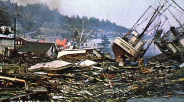
Top Left: Downtown Kodiak in the aftermath of the Tidal Wave, showing the boats and buildings tossed far inland by the wave (from a post card). Bottom Right: Huge fishing tenders were tossed far inland, and boats sank in the channel and harbor, making navigation hazardous for months afterward. (Georgia Smith photo)
The devastation to Kodiak was severe, with the destruction of all of the low-
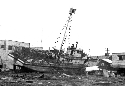
Left and Below: Famed author, skiff builder and rancher Ed and Anna Opheim’s place at Pleasant Harbor, down Spruce Island from the village, before and after the Tidal Wave.
For more articles on Kodiak and Ouzinkie history,
and many more historic photos,
please follow the link in the “Online Articles” logo below.
To Find Out More About Tanignak.com, Click HERE
To Visit My “About Me” Page, Click HERE
To Return to Tanignak “Home,” Click the Logo Below:
Information from this site can be used for non-
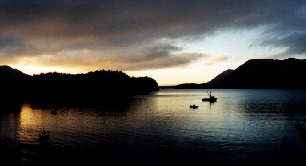
A peaceful sunrise over Ouzinkie harbor in October of 1996. Fully recovered, forever changed.
Thanks to Jeannette Chernikoff and my brother Kelly for corrections!




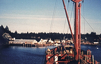
Approaching Ouzinkie in the sunset on the Alaska Standard oil tanker, taken 3/25/64, just two days before the Tidal Wave changed the harbor forever.
This was the last photo ever taken of the Ouzinkie Packing Company cannery and the houses along the shore before it was all destroyed on 3/27/64.
New for the 60th Anniversary of the Alaska Quake:
“Alaska Earthquake” sung by Blue Ervin
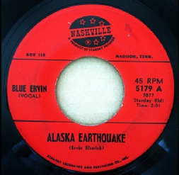
The “Alaska Earthquake” Song, a 45rpm record by Blue Ervin. It was played on Alaska
radio stations in the summer of 1964, but it took me almost 60 years to identify
the artist and then to find a copy of this very rare record. The song mentions Kodiak
and the many other communities affected by the disaster. The restored file is presented
here in a mild “stereo-
